History of Manchester Connecticut
by Mathias Spiess and Percy W. Bidwell, PhD.
1924
pp. 29-32
The Purchase of the Five Miles.
Our community was known as “the wilderness” until the year 1672 when Major John Talcott of Hartford bargained with Chief Joshua the third son of Uncas the Mohegan sachem, for a certain tract of land about five miles square. The record of this begins as follows: “Whereas, Joshua Sachem, some short time before his death, did make a Sale of a Parcel of Land to Major Talcott, of Hartford, and the said Joshua Sachem Deceasing before he had made conveyance of his Will reciteing his said bargain and disposing of the said pay agreed on for the said Lands for the use of his children of him the said Joshua, as more at length is expressed in the said Will, and the child of the said Joshua now needing the purchase for the use of the said child,” etc. At a town meeting held in December, 1681, the 'town by their vote agreed to pay to the executors or administrators of Joshua's will, as much money as Major Talcott agreed with Joshua for the land within the bounds of the township of Hartford, proportionate to what they receive or lies within the township of Hartford, provided those that receive the money give sufficient deeds to the Town of Hartford for the conveying of the said land to them and holding it firm to them and their heirs and successors forever.”
The tract was deeded to Cyprian Nichols, Sergeant Caleb Stanley and John Marsh, selectmen of the Town of Hartford, dated May 13, 1682, by Captain James Fitch of Norwich, and Thomas Buckingham of Saybrook, administrators of the estate of Sachem Joshua.
In the minutes of a town meeting held at Hartford, December 27, 1683, we read “The deede and sale ffor ffive myles in Length and all the Bredgth of Hartford Bounds ffor Land Bought of Joshua Uncas son: or his administrators or agents Camp James ffitch & Mr. Tho Buckingham: was givne to Camp Allyn to Recorde, and also Mr. Allyn was desired to Recorde the Town Rate in 82 for a rule to distribut the said Trackt of Land by according to each mans payment or purchas in sd Rate.”
The town rate mentioned was brought up in a town meeting December 28, 1682, when “the Towne granted a rate of Eighty Three pounds and Tenn shillings to defray the Towne Charges this present yeare.” It was also voted at a meeting held January 9, 1682, that “the last grant of land to this Town of Hartford made by the General Court on the east side of the great River shall be divided amongst the Inhabitants of the Towne according to what they shall pay to the Indian purchass of this land, & whereas there are some grants made of some lands by the General Court to perticular persons within the five miles of land granted to the Towne on the east side of the River The Towne doe appoynt Major Tallcott, Mr. Nicolls Ens: Standly & Nath willett or any Three of them to be a committee to (view those grants & other lands & to consider the quantity & quality of it those Grants)1 agree what of rights those grants shall pay to the purchase of the aforesayed Tract of land bought of Joshua's Administrators & the remaynder of the lands is to be divided amongst the Inhabitants as aforesayed. Att the same meeting the Towne by thayr voate Chose Major Hno Tallcott: Capt Jno Allyn Mr. Nicolls Engs Stanly and Mr. Wm Gibbon to be a Committy to Consider of The Best Moddle of that Trakt of Land on the East side the great River above mentioned shall bee divided and make thayr Return unto the Town of thayr Considerations about the said Land.”
Nothing was done, however, during the next fifty years, as far as division of land was concerned, although in 1729 it was "voted that two miles next Bolton with highways be laid out at present in two divisions.” The rest of the land was to remain undivided for further consideration, but, as in 1682, nothing was done. The vote of 1729 included a highway ten rods wide which was ordered to be laid out "next Bolton line” and twenty rods between two divisions for a highway from Windsor to Glastonbury. It was further ordered that a parcel of land be sold to pay the expenses of the layout.
The First Distribution of Land, 1731.
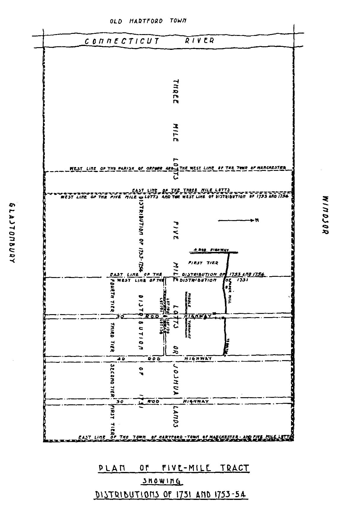
The matter rested for two years longer but in 1731 activity began and the first distribution of land took place according to the town vote of 1729. Four distributions followed and the last of the “teer of lots,” as they were called, was laid out and surveyed by William Wells in the year 1753. Of this an old map still exists, a copy of which is reproduced below.
 Click to enlarge
William Wells gave an account of his work as follows: “These may certifie all whom it may concern that I the Subscriber did In Feby 1753, on the desire of Mess Samll Wells, Camp. Ausmore (Hosmer) Josiah Olcott & John Haynes Lord, Gentn appointed by the proprietors of Hartford to measure the whole of the commons & grants Layd out in sd Commons on the East side of the Great River in said Hartford between the Three mile lots so called & the fourth teer of lots in the five miles so called, we began at a Ditch in the Dividing Line between Hartford and Glassonbury at the East End of the Three mile Lots & Run and measured East five hundred and seventy four rods to Thomas Keeney's house at the south west end of the fourth Teer of Lots. Then we run north 1 degree East four miles & a half to a white oak staddle marks in the dividing line between Hartford and Windsor, Then we run west four hundred and ten Rods in Windsor Line to the East end of the three mile Lotts. Then we run south 6 degrees & 20 m. west on the line of ditches on the east end of three mile lotts to the first mentioned bounds and have measured the grants & put the mens names and number of acres in said grants as I have Sayd in this plan. So the whole of the Commons & Grants Contained 4428 acres of Land. The grants contain 1305 acres & 100 rods, which subtracted out there remains 3122 acres & 60 rods of Land to be divided.
“surveyor.”
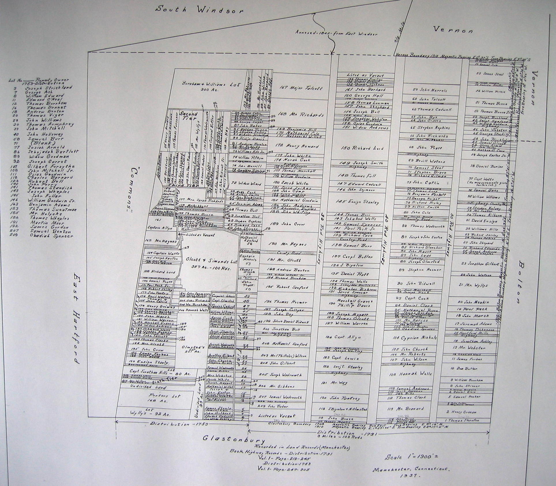
The following detailed map of the Five Mile Tract was obtained at the Manchester Town Hall and contains the specific distributions of 1731 and 1753 (the file is large to capture detail).